Korean Tourist Destination Route – Business Management Diagram
RJ0800022_12
- Last Update 08/05/2025
- File Size 7.8MB
- # of Slides 2
- File Format PPTX
- Slide Ratio 16:9
- Color
Keywords
- #Content-Based Slides
- #Design-Based Slides
- #Business Management
- #Diagram
- #Other
- #Execution Plan
- #Implementation Plan
- #Cluster
- #Closed Cluster Diagram
- #16:9
- #Korean tourist destination map PowerPoint
- #tourism route diagram slide
- #regional route map template
- #Korea map presentation
- #business management map slide
About the Product
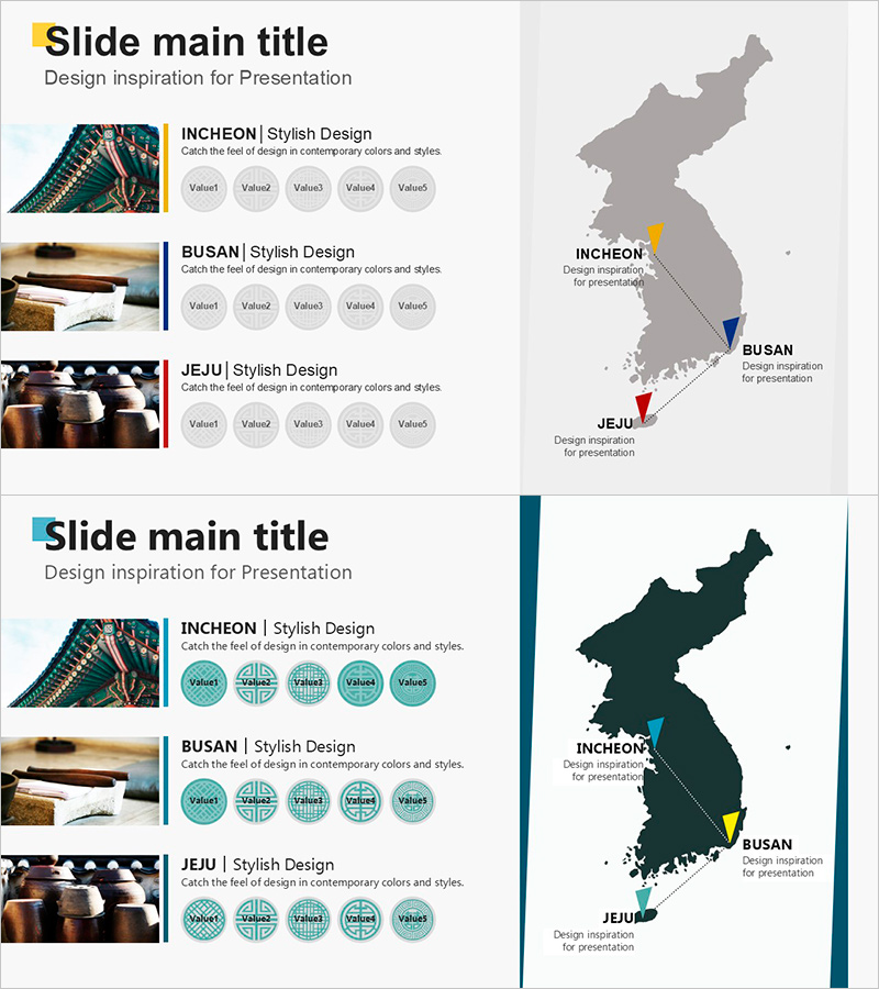
A closed-form map diagram PowerPoint slide displaying major Korean tourist destinations with directional arrows connecting three key locations: Incheon, Busan, and Jeju. Each point is distinguished by color-coded markers (yellow, blue, red) for clear route visualization. The 2-slide set includes both grayscale and color-tone versions in 16:9 widescreen PPTX format, fully editable for tourism presentations, business management, regional network strategies, and travel planning. Ideal for travel agencies, tourism boards, regional marketing teams, and logistics companies.
Usage Points
-
Main Usage
Visually communicate travel routes between major Korean destinations and spatial relationships for tourism, business expansion, and regional network presentations. The map-based diagram with pointers and connecting arrows clearly conveys flow and connectivity.
-
How to Use
Add text, data, and labels to explain tourism routes, regional business development plans, or network expansion strategies. Choose the grayscale version for corporate presentations or the color version for tourism and marketing pitches.
-
Recommended For
Travel agencies, tourism boards, regional marketing departments, business development teams, logistics and distribution companies presenting destination routes, tourism products, or network expansion plans.
-
Slide Structure
Slide 1: Grayscale Korean map with three location markers (Incheon-yellow, Busan-blue, Jeju-red) connected by directional arrows. Slide 2: Identical structure with color-tone design featuring teal background and accent lines for enhanced visual impact.
Related Products
-

Providing Direction for Global Development – Effective Implementation through Business Management and Clustering
#Business Management #Diagram #Other
-

Diagram Slide Template for Career Development Plan
#Business Management #Diagram #Execution Plan
-

Main Keyword Connection Diagram - Suitable for Business Management and Planning
#Business Management #Diagram #Execution Plan
-

Rocket Launch Progress by Country – Systematic Data Presentation
#Market and Competitor Analysis #Marketing Plan and Strategy #Diagram
